


Gunlock #VE80.3 Voting District, Washington County, Utah
About
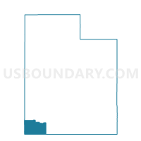
Outline

Summary
| Unique Area Identifier | 680419 |
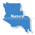
| Name | Gunlock #VE80.3 Voting District |
| County | Washington County |
| State | Utah |
| Area (square miles) | 112.00 |
| Land Area (square miles) | 111.60 |
| Water Area (square miles) | 0.40 |
| % of Land Area | 99.64 |
| % of Water Area | 0.36 |
| Latitude of the Internal Point | 37.30055890 |
| Longtitude of the Internal Point | -113.72283470 |
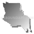
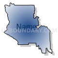
Maps


Graphs
Select a template below for downloading or customizing gragh for Gunlock #VE80.3 Voting District, Washington County, Utah


Neighbors
Neighoring Voting District (by Name) Neighboring Voting District on the Map
- Dammeron Valley #DAV83 Voting District, Washington County, UT
- Diamond Valley #DIV92 Voting District, Washington County, UT
- Ivins #IV76 Voting District, Washington County, UT
- Ivins #IV77 Voting District, Washington County, UT
- Ivins #IV78.1 Voting District, Washington County, UT
- Outside Cities and Towns #OUT1 Voting District, Washington County, UT
- Outside Cities and Towns #OUT2 Voting District, Washington County, UT
- Outside Cities and Towns #OUT3 Voting District, Washington County, UT
- St. George #SG14 Voting District, Washington County, UT
- St. George #SG15 Voting District, Washington County, UT
- Veyo #VE80.1 Voting District, Washington County, UT
- Winchester Hills #WH98 Voting District, Washington County, UT
Top 10 Neighboring County Subdivision (by Population) Neighboring County Subdivision on the Map
Top 10 Neighboring Place (by Population) Neighboring Place on the Map
- St. George city, UT (72,897)
- Ivins city, UT (6,753)
- Dammeron Valley CDP, UT (803)
- Veyo CDP, UT (483)
Top 10 Neighboring Unified School District (by Population) Neighboring Unified School District on the Map
Top 10 Neighboring State Legislative District Lower Chamber (by Population) Neighboring State Legislative District Lower Chamber on the Map
Top 10 Neighboring State Legislative District Upper Chamber (by Population) Neighboring State Legislative District Upper Chamber on the Map
Top 10 Neighboring 111th Congressional District (by Population) Neighboring 111th Congressional District on the Map
Top 10 Neighboring Census Tract (by Population) Neighboring Census Tract on the Map
- Census Tract 2707, Washington County, UT (9,725)
- Census Tract 2703, Washington County, UT (8,148)
- Census Tract 2705, Washington County, UT (7,423)
- Census Tract 2704, Washington County, UT (6,218)
- Census Tract 2702, Washington County, UT (3,074)